


- Dangerous severe thunderstorms are expected in the South now through Friday.
- Tornadoes, widespread damaging winds and large hail are all threats.
- Flash flooding is also a serious danger.
A dangerous severe weather outbreak will get underway in the South later today and could produce long-lived, intense tornadoes as well as widespread damaging winds, large hail and flash flooding.
Here is what you need to know about the current situation and what’s to come.
Latest radar, storm reports: Showers and thunderstorms are ongoing in the South right now.
Overnight, hail up to the size of softballs reportedly crashed through the roofs of mobile homes and truck windshields near Dilley, Texas. A tornado was reported near Shottsville, Alabama.

Dangerous severe weather expected later today and tonight: The most widespread threat of severe thunderstorms appears to be Thursday afternoon and Thursday night across parts of the Deep South. The threat is highest in the darkest-color contours shown below. In their Thursday morning outlook, NOAA’s Storm Prediction Center said “a regional severe thunderstorm outbreak appears likely” in the area below, including threats of large hail, widespread damaging winds, and tornadoes, some of which may be intense.
Multiple rounds of severe thunderstorms are possible in some areas. Supercell thunderstorms packing tornado, very large hail and damaging wind threats could develop initially in central and northern Texas, southeast Oklahoma, southwest Arkansas and northwest Louisiana. Then, a squall line of severe storms packing destructive straight-line winds and tornadoes will track from eastern Texas to the lower Mississippi valley through the evening and overnight.
(MORE: What Is A Squall Line?)

Flash flooding is also a serious concern Thursday: Locally heavy rain may result in flash flooding, with the greatest threat Thursday and Thursday night. Areas from eastern Oklahoma and northeast Texas into much of Arkansas, southeastern Missouri, western Kentucky and western Tennessee are especially at risk.

The severe thunderstorm threat may last into Friday: Parts of the Southeast northward to near the Ohio Valley may see some severe thunderstorms Friday and Friday evening. Areas from eastern Mississippi into Alabama, Georgia, far northern Florida, Tennessee, the Carolinas, southwestern Virginia, southern West Virginia, Kentucky and parts of southern Ohio and Indiana are included in the severe risk Friday. Damaging thunderstorm wind gusts and tornadoes are possible.

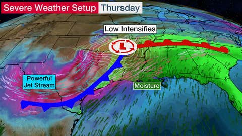
Here’s why this is expected to be an outbreak: The setup for this outbreak is straight out of a weather textbook. A powerful jet stream will surge eastward into the South. That will cause low pressure to intensify (possibly to threaten Southern low-pressure records) and pull warm, humid air northward. The volatile mix of instability, wind shear (the change in wind direction and speed with height), moisture and lift has meteorologists concerned about widespread severe thunderstorms with damaging winds and the potential for stronger tornadoes.
Here’s what you need to do: If you’re in these areas, make sure you’re prepared for severe weather. Have multiple ways of receiving watches and warnings from the National Weather Service, including NOAA weather radio and a smartphone app that can alert you even if you’re sleeping. Know where to go to seek shelter when a warning is issued. If you live in a home without a basement or in a mobile or manufactured home, we have important safety tips here.
The Weather Company’s primary journalistic mission is to report on breaking weather news, the environment and the importance of science to our lives. This story does not necessarily represent the position of our parent company, IBM.
0 Comments :
Post a Comment